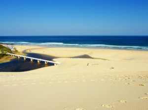
 Over the last two days I have featured the view of the beach at Maitlands as well as the Maitlands dune. Today I want to finish off the visit to Maitlands with a picture of the view from the dune. Ok, so I didn’t climb to the top, but I was still pretty high up the dune. Anyway, been there, done that. Looking down you can see the Maitlands river mouth and the lagoon. Port Elizabeth is situated to the left (east) of the picture. The pipes across the river is the main water supply line to Port Elizabeth from the city’s water supply dams which are all situated in the Kouga area to the west of the city.
Looking down from Maitlands dune
 Over the last two days I have featured the view of the beach at Maitlands as well as the Maitlands dune. Today I want to finish off the visit to Maitlands with a picture of the view from the dune. Ok, so I didn’t climb to the top, but I was still pretty high up the dune. Anyway, been there, done that. Looking down you can see the Maitlands river mouth and the lagoon. Port Elizabeth is situated to the left (east) of the picture. The pipes across the river is the main water supply line to Port Elizabeth from the city’s water supply dams which are all situated in the Kouga area to the west of the city.
This Post Has 5 Comments
Comments are closed.
That's a BIG beach! Beautiful sky and ocean – oh to be able to stroll along there . . . you are lucky!!
We used to go to these beaches when I was a kid and 'ride' the dunes on boards. We also used to swim in the lagoon! Thanks for the memory jog!
Simply Wow!Nice beach with calm and deep blue sky…Greatness of god!
Wow – that's PE's main water supply? Looks a little vulnerable! Love the colours, especially the tea-coloured river water in contrast to the white sand.
I went down on a plywood board lying down from the top. My wife was on top of me and we were both lying down. We went so fast that we went straight over the water to the other side. Dont think I will try it again!