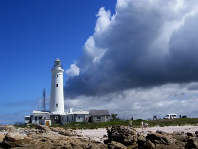
 The area about 65 – 120km west of Port Elizabeth is known as the Kouga (Place of many fat animals). The coastal towns of the Kouga is situated around the Bay of St Francis. Included in the area is the surfing and shell town of Jeffreys Bay, the very upmarket marina canal village of St Francis Bay and then the western point of the Cape St Francis. At the point is the Seal Point Lighthouse built in 1878. It used to be one of the stops on one of my tours. On this day there was a cold front approaching and the dark clouds were moving in fast.
Storm front moving in
This Post Has 5 Comments
Comments are closed.

Hi Firefly, thanks for stopping in and the comments.The wind at he lighthouse was something to behold today – we were almost blown off our feet. It was also amusing watching the cormorants trying to fly into the wind and going backwards.I have decided to try and sort out the blogger problems, because I prefer it to WordPress. I am doing this with my cell phone.
Your photo blog is absolutely exquisite. I just looked through all your photo posts, and omigosh!! It’s wonderful to see them, and to see names of places my mother used to talk about.You know, there are lots of “photo contest” blogs in the blogosphere, and I think you could win all of them – hands down!More, more, more! 🙂
Another cracking shot, amazing clouds, stunning, this would make a great print.
Hi Firefly, thanks for stopping by my place. This is an amazing sky. I’ve never seen a sky divided like that with heavy storm clouds on one side and clear on the other. I’ve looked through some of your shots. I love the lions and elephants photos. Nicely done 🙂
Wow, love this pic, the sky is awesome!