
A road trip to East London from Port Elizabeth along the N2 via Grahamstown. The historic Fort Peddie in the town of Peddie dating back to the Frontier Wars. A geocache. These three things added up to a great solo adventure a couple of weeks ago. I’ve been eyeing the cache at Fort Peddy for a while now but a trip to East London for a meeting was the excuse to do it.
This fort was built in 1835 on the banks of the Hlosi River and named after Colonel John Peddie, commanding officer of the 72nd Regiment (Seaforth Highlanders). In May 1846, during the War of the Axe, Fort Peddie successfully withstood an attack from about 10 000 Xhosa warriors led by Chief Dilima. None of the people manning the fort were hurt or killed.
The fort consists of a tower and cavalry barracks, both of which are still visible. This tower is one of many built to try and improve communication between Fort Beaufort and Fort Selwyn in Grahamstown. The idea was to build a line of towers within telescopic sight to communicate messages between each other. There were two lines known as the Peddie Line and the Beaufort line. Communication was done by the use of a semaphore, a type of signaling mast first developed by Claude Chappe during the French Revolution. The remains of a semaphores can be viewed if you climb to the top of the tower.
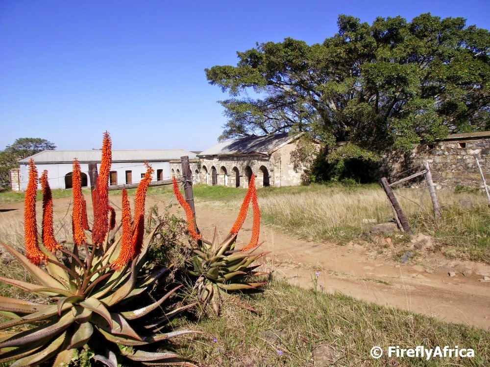
The cavalry barracks is just down the hill from the tower. The barracks and accompanying stables were built in 1840. They were first used as living quarters for the Cape Mounted Riflemen and the 7th Regiment, led at the time by Colonel Henry Somerset, son of Lord Charles Somerset, Governor of the Cape. During the 7th War of Land Dispossession of 1846, these two units created a turning point in the hostilities by successfully repulsing Xhosa warriors at the Battle of uMgwangqa about 6 kilometers from Peddie.

But back to my adventure. The cache is located on top of the tower and I knew I had to take a “special tool” along. The special tool being my fold up ladder which although it fits in my boot can also unfold to be about four meters tall. The ladder of cause was necessary to get me in the tower’s door which is about 3 meters up with no steps. Inside the tower I found no floor so I had to pull the ladder in to be able to climb down and up on the other side again. From there it was up a rusty ladder attached to the top of the tower bouncing only slightly less than my heart as I climbed to the top. After enjoying the view I started my search and found the cache container … no, I won’t tell you where. Log sheet signed and container returned it meant that it was now time for me to make the return journey down the ladder and back towards the door. Mission accomplished. One more stop took me for a look around the old stables and shortly after I was back on the road towards East London. If I wasn’t a Geocacher, would I have done the little detour to go and have a look at the fort? Probably not. It would also have meant that I would never had discovered this historic spot. Geocaching doesn’t just turn one into a modern treasure hunter, but also into an explorer.
It's a good combination of geocaching to get you out and about. Love the buildings.
When I was a child you could climb into the fort and up to the top. No ladders needed. I lived in the Peddie district from 1967 to 1980 when we were 'expropriated'. A polite term for forcibly removed.