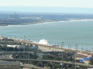
One of the prime beaches in Port Elizabeth in the early years was the North End Beach. If you look at this article on tall ships wrecked in a massive gale, the ships shown in the vintage photographs were stranded on North End Beach. Sadly the land was taken over by the Railways, and a large portion along the beautiful beach was reclaimed, and is now taken up by railway lines and overhead cables. (Our city fathers in the town planning department have a lot to answer for!)
The sea is held back by dolosse strewn along the high tide mark, although in severe gales and spring tides, it does occasionally wash over the main N2 freeway that runs parallel to the railway lines. (I will do a post later today on my blog to explain more about dolosse, just need to pop down to the Dock of the Bay restaurant for a nice lunch of fresh fish…. we are relaxing at Port St Francis at the moment!)
edit……mmmmm…….that was yummy, fresh Cape Salmon… but I digress, the dolosse post is here


A nice lunch of fresh fish sounds divine! The sea is beautiful yet dangerous when gales and strong. Your photo is very appealing because it shows the water so well.
Oddly enough it looks just like Switzerland they have a ‘super-highway’ and train tracks running really close to Lac Leman/Lake Geneva. Which is a bit disturbing but still breathtaking, like Port Elizabeth :-). Have a good weekend.
Wonderful view.Enjoy your meal!
Wow, beautiful view. I hope you enjoyed your meal.